Written by Elena Vasquez, maritime historian and travel writer with 12 years covering South American geography and ocean exploration routes.
You’re staring at a map of South America, tracing your finger to the very bottom of the continent. The land just… ends. And between that jagged tip and a maze of islands, there’s a thin, twisting blue line connecting two of the world’s largest oceans.
That line is the Strait of Magellan — and it’s one of the most consequential bodies of water in human history. If you’ve ever wondered why sailors feared it, why explorers died trying to find it, and why it still matters in an age of satellites and supertankers, this article gives you the full picture.
What Is the Strait of Magellan?
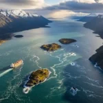
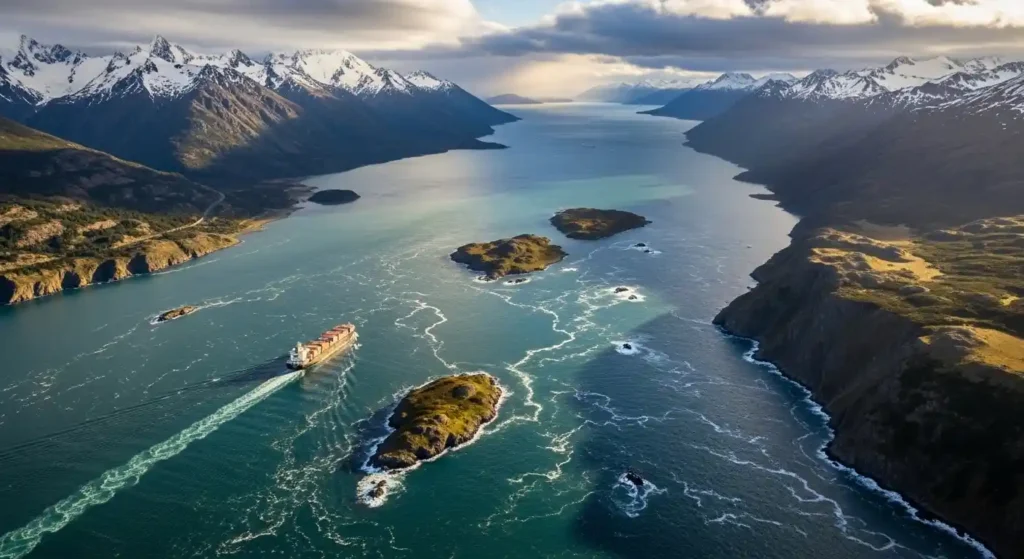
The Strait of Magellan is a natural navigable sea route at the southern tip of South America, separating mainland Chile and Patagonia from the Tierra del Fuego archipelago. It connects the Atlantic Ocean on the east to the Pacific Ocean on the west.
Here are the key facts:
- Length: Approximately 570 kilometres (350 miles)
- Width: Varies from 2.2 km at its narrowest to about 32 km at its widest
- Location: Between latitudes 52°S and 55°S in southern Chile
- Administered by: Chile, with Punta Arenas as the main city on its shores
- Water depth: Deep enough for modern vessels in most sections
Unlike a man-made canal, this is a naturally occurring channel carved by glacial activity over thousands of years. The surrounding terrain — sheer cliffs, glaciers, dense sub-Antarctic forests — makes it one of the most dramatic waterways on Earth.
The Strait of Magellan Explained Through a Real Moment in History
Picture this: it’s 1520. Ferdinand Magellan, a Portuguese explorer sailing under the Spanish crown, has been at sea for over a year. His crew is exhausted, mutinous, and running low on food. He’s searching for a westward route to Asia — a route nobody has confirmed exists.
On October 21st, he spots a cape at the tip of South America. He sends two ships ahead to scout. When they return, the officers report something almost unbelievable: a channel that doesn’t dead-end. It keeps going west.
It took Magellan 38 days to navigate the full passage. The winds were violent. The currents unpredictable. Three of his five ships made it through. He named the waters the “Sea of Patagonia.” Later mapmakers renamed it in his honour.
That crossing changed the world’s understanding of its own geography. Before Magellan, European maps showed South America ending in uncertainty. After 1520, they showed a route — dangerous, but real.
How to Navigate the Strait of Magellan: What It Takes
Whether you’re a sailor planning a passage or a traveller taking a cruise, understanding how navigation actually works here is essential. This is not a casual waterway.
Step-by-step breakdown of a modern transit:
- Enter from the Atlantic side near Cabo Vírgenes (the eastern entrance) or from the Pacific near Cabo Pilar in the west
- File a transit plan with Chilean maritime authorities — this is legally required for all vessels
- Hire a Chilean pilot — mandatory for ships over 50 metres in length
- Monitor weather windows — conditions can shift within hours; squalls arrive without warning
- Navigate the First and Second Narrows, the tightest sections where tidal currents run strongest
- Anchor at Punta Arenas mid-passage if needed — it’s the only significant city along the route
- Complete customs and port clearance before exiting into the Pacific
Modern commercial ships use GPS, depth-sonar, and real-time weather data. Even so, Chilean pilots remain compulsory because local knowledge — current patterns, micro-weather, hidden shallows — cannot be fully replaced by technology.
Antarvacna: Meaning, Use, and Deeper Significance
Common Mistakes and Misconceptions About the Strait of Magellan
People get several things wrong about this passage. Here’s what to stop believing:
Mistake 1: “It’s always safer than Cape Horn.” Not always true. The Strait has its own dangers — narrow sections, kelp beds, sudden winds called williwaws, and reversing tidal currents. For smaller vessels, the strait can actually be more technically demanding than running offshore around Cape Horn in calm conditions.
Mistake 2: “Magellan discovered the Pacific Ocean.” He didn’t. Vasco Núñez de Balboa crossed Panama and saw the Pacific in 1513 — seven years earlier. What Magellan discovered was a navigable sea route connecting the two oceans from Europe’s perspective.
Mistake 3: “The strait is in Argentina.” The entire strait falls within Chilean territory. Argentina borders the Atlantic entrance region, but the passage itself is Chilean.
Mistake 4: “It’s only a historical curiosity now.” Wrong. The Panama Canal handles most cargo traffic today, but the Strait of Magellan remains an active commercial route — especially for vessels too large or too laden with certain cargo to use the canal.
Strait of Magellan vs. Drake Passage vs. Panama Canal
| Feature | Strait of Magellan | Drake Passage | Panama Canal |
|---|---|---|---|
| Type | Natural strait | Open ocean passage | Man-made canal |
| Location | Southern tip of South America | Below Cape Horn | Central America |
| Length | ~570 km | ~800 km wide ocean | ~80 km |
| Difficulty | Moderate–High (winds, currents) | Very High (world’s roughest seas) | Low (controlled locks) |
| Time to transit | 24–72 hours | 2–4 days | 8–10 hours |
| Cost | Moderate pilot fees | Free (open sea) | High canal tolls |
| Scenery | Spectacular fjords and glaciers | Bleak open ocean | Tropical rainforest |
| Best for | Adventurous cruisers, freighters | Tall ships, very experienced sailors | Commercial cargo |
The Drake Passage is wider and often rougher — the seas below 60°S are among the most violent on the planet. The Strait of Magellan is calmer by comparison, but requires far more precise navigation. The Panama Canal is faster and safer, but expensive and unavailable to very large ships.
Pro Tips for Anyone Visiting or Researching the Strait of Magellan
If you’re travelling there as a tourist:
- Punta Arenas is your gateway city — fly into here from Santiago
- The best months are November through March (austral summer) for calmer seas and longer daylight
- Book a cruise that includes a passage transit, not just a scenic coastal trip — the difference is significant
If you’re a sailor planning a passage:
- File all documentation with DIRECTEMAR (Chilean maritime authority) well in advance
- Budget extra time — weather delays of 3–5 days are common even in summer
- Carry paper charts as backup; electronic charts of this region have been known to contain errors
The insight most articles miss: The Strait of Magellan is ecologically extraordinary. Its waters are home to Magellanic penguins, southern right whales, and Commerson’s dolphins. Several conservation zones along its length restrict commercial fishing. For wildlife photographers, the strait rivals the Galápagos for density of marine species — yet almost nobody talks about it in that context.
Frequently Asked Questions
How long does it take to sail through the Strait of Magellan?
For a commercial vessel moving at normal speed, the transit takes between 24 and 36 hours. Smaller yachts often take 3–5 days, factoring in weather delays and mandatory anchoring.
Is the Strait of Magellan dangerous?
It carries real risks — sudden williwaw winds, strong tidal currents in the narrows, and unpredictable weather. With proper preparation, licensed pilots, and modern navigation equipment, most transits are completed safely. Historically, it was far more deadly.
Can tourists visit the Strait of Magellan?
Yes. Punta Arenas, Chile’s southernmost major city, sits directly on the strait. Cruise ships offer passage transits, and day tours operate from the city. The Magallanes and Chilean Antarctic Region is an established tourism destination.
Why didn’t ships use the Strait of Magellan more after Magellan’s voyage?
It took decades for the route to become trusted. Early charts were inaccurate, and the passage earned a terrifying reputation. Many captains preferred to risk rounding Cape Horn in open water rather than navigate the tight channels. It wasn’t until the 19th century that the strait became a preferred route.
Does the Strait of Magellan still have commercial importance?
Yes. While the Panama Canal handles the majority of inter-ocean commercial traffic, the Strait of Magellan serves vessels that are too wide for the canal (even after its 2016 expansion), and those carrying cargoes not permitted in the canal. Chilean ports along the strait also serve the Patagonian fishing and aquaculture industries.
The Strait of Magellan — Still Worth Understanding
Five hundred years after Magellan’s terrifying 38-day passage, the Strait of Magellan remains one of the most geographically and historically significant waterways on Earth. It’s not just a line on a map — it’s the route that proved the world was circumnavigable, a living ecosystem of rare marine wildlife, and an active commercial corridor that modern shipping still depends on.
If you’re planning a trip to Patagonia, add a strait transit to your itinerary. If you’re researching ocean geography or exploration history, start here — everything connects back to this narrow, wind-battered channel at the bottom of the world.
Your next step: Look up cruise operators that offer a full Strait of Magellan transit (not just a coastal cruise) departing from Punta Arenas. The difference between seeing it from a distance and actually passing through it is something you won’t forget.